
PL 19 Klagenfurt am Wörthersee 1:17 500 / plán města
Výrobce: Freytag & Berndt
EAN: 9783850841191
Typ produktu: Mapy, atlasy
Pořadí vydání: 1.
Objednací číslo: 0563717
Stadsplattegrond met register. Helder kaartbeeld waarbij de naamgeving goed leesbaar is weergegeven. Met de toeristische bezienswaardigheden in symbolen weergeven: monumenten, musea, stadions e.a. Daarnaast handige zaken als postkantoren, parkeergarages en stations. Veelal ook met een openbaar vervoer of metro kaart...
Číst více 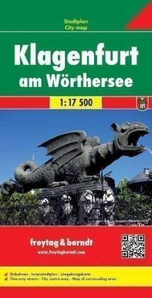

Cena v eshopu
248 Kč
222 Kč

Doporučené tituly a kolekce


Ostatní si taky prohlížejí


-34 Kč

-34 Kč

-26 Kč

-34 Kč

-34 Kč

-26 Kč

-152 Kč

-34 Kč

-34 Kč

-26 Kč

-34 Kč
Více o produktu
POPIS
PODROBNOSTI
KATEGORIE
Stadsplattegrond met register. Helder kaartbeeld waarbij de naamgeving goed leesbaar is weergegeven. Met de toeristische bezienswaardigheden in symbolen weergeven: monumenten, musea, stadions e.a. Daarnaast handige zaken als postkantoren, parkeergarages en stations. Veelal ook met een openbaar vervoer of metro kaart als inzet
Freytag and Berndt, Austria's leading map publishers, produce a series of street plans covering the country's main cities. All the plans are indexed and show public transport system. Plans of cities in the mountainous parts of the country are contoured to indicate the terrain. Most plans have enlargements showing the town centre in greater detail. Some plans include a black and white map of the city overprinted with cycle routes. Map legend includes English.
Výrobce:
Typ produktu:
Mapy, atlasy
Vazba:
Ostatní (neknižní zboží)
Pořadí vydání:
1.
Výška:
256 mm
Šířka:
132 mm
Hloubka:
13 mm
Hmotnost:
118 g
Ean:
9783850841191
Vybíráme pro vás

-34 Kč

-34 Kč

-23 Kč


-34 Kč

-34 Kč

-90 Kč

-34 Kč


-35 Kč


-34 Kč

-49 Kč


-46 Kč


-17 Kč
